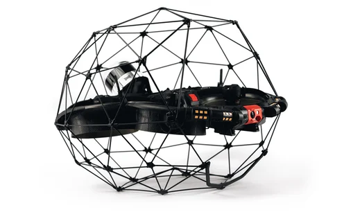
Safety The Elios 3 was able to access every part of the bridge, including hard-to-reach areas that would normally require scaffolding or work at height. The drone was flown in a way that ensured no distraction to traffic, making it a safe and efficient alternative for bridge inspections. Efficiency Thanks to the Elios 3’s advanced capabilities, the entire bridge was mapped in just four flights, completed within a single day. This approach significantly reduces inspection time and avoids the need for traffic redirection, saving both time and resources. Accuracy The Surveying Payload achieved over 90% data accuracy within 1 cm, delivering highly detailed and precise results. This level of precision is essential for identifying structural issues and planning maintenance effectively. Business Development Despite not flying directly over the live bridge deck, the team successfully captured the full structure using the Surveying Payload. This demonstrates the payload's versatility and effectiveness in real-world conditions. Flyability launched the Elios 3 Surveying Payload in October 2023, aiming to provide a high-precision LiDAR solution for its flagship drone. With their partner Droprise, they tested the new payload on a road bridge survey, showcasing its potential for infrastructure monitoring and maintenance. The Elios 3 offers two LiDAR options tailored to different needs. The standard Rev 6.2 LiDAR is ideal for general area surveys where moderate accuracy is sufficient. In contrast, the Surveying Payload features the more advanced Rev 7 LiDAR, designed for high-accuracy mapping in complex environments such as underground mines, sewers, and bridges. It delivers up to 1.3 million points per second and has a range of up to 100 meters, ensuring comprehensive and detailed data collection. The Surveying Payload, paired with FARO Connect software, enables automated point cloud merging and noise reduction, streamlining the data processing workflow. During testing, over 90% of the collected data was accurate within 2 cm, proving its reliability and efficiency in challenging environments. Droprise, a long-time Flyability partner since 2019, specializes in drone-based inspection and surveying services across construction and infrastructure projects. Based in Bruges, Belgium, they wanted to showcase the Elios 3 Surveying Payload’s capabilities in a real-world setting that would highlight its value to potential clients. They faced a challenge: local clients required clear proof of ROI before adopting new technology. To meet this demand, they chose to test the Elios 3 on a busy motorway bridge, demonstrating how it could collect high-quality data without disrupting traffic. The Elios 3 Surveying Payload successfully mapped the entire bridge without interfering with traffic. With permission from local authorities, a team from Droprise and Flyability conducted the survey around the bridge, avoiding direct flight over the active road. They focused on collecting data from beneath and alongside the structure, creating a complete 3D model of the bridge. The Elios 3’s unique design allows it to operate without GPS, relying instead on visual-inertial odometry (VIO) and LiDAR stabilization. This makes it ideal for navigating tight spaces and complex structures where other drones might struggle. It also supports Remote ID, an important feature for compliance in markets like the US. Because the Elios 3 doesn’t rely on GPS, it can fly close to or under bridges without losing signal, making it a safer and more reliable option for infrastructure inspections. The team carefully planned their flights to avoid distracting drivers while still capturing all necessary data. The bridge, built in 2014 and partially over water, presented an ideal test case. Traditional methods of inspecting the underside would require expensive scaffolding, but the Elios 3 made it possible to gather detailed data quickly and safely. This kind of non-invasive inspection is becoming increasingly valuable as infrastructure ages and maintenance becomes more frequent. The LiDAR data captured by the Elios 3 provides stunning clarity and detail. The 600-meter-long bridge was surveyed from multiple angles in just four flights. The pilot maintained a safe distance from the highway, flying close to the underside to capture all key details. With the Rev 7 LiDAR recording 1.5 million points per second, the resulting point cloud was extremely dense and detailed. Using FARO Connect, the team aligned the data from each flight and created a full 3D model of the bridge. This process demonstrated the power of the Surveying Payload and its ability to deliver high-quality results efficiently. The final point cloud of the bridge showcased remarkable clarity and detail, offering a comprehensive view of the structure despite being captured from limited angles. This data is invaluable for assessing the condition of the bridge and planning any necessary maintenance. Droprise now has a powerful tool to demonstrate the quality of data to potential clients. This project is particularly relevant for large-scale infrastructure management across Belgium. Looking ahead, they plan to conduct a follow-up flight using georeferencing to enhance the accuracy and create a fully localized, centimeter-precise model of the bridge. The Swiss slitting machine tool, also known as the Swiss lathe or core lathe, differs from a conventional knife lathe in that it features longitudinal cutting via spindle extension movement rather than tool rest extension movement. Its primary advantage lies in its ability to turn slender shaft parts with diameters below 3mm and length-to-diameter ratios greater than one. Cnc Sliding Head Machine,Sliding Head Lathe,Sliding Head Machine,Sliding Head Cnc Ningbo Leyan Machinery Technology Co., Ltd , https://www.cncleyan.comTesting the Elios 3 Surveying Payload: Mapping a 600m Bridge Without Disrupting Traffic
Flyability, in collaboration with its partner Droprise, recently conducted a groundbreaking survey of a 600-meter-long bridge in Belgium using the Elios 3 drone equipped with its new LiDAR Surveying Payload. This innovative project aimed to demonstrate how advanced drone technology can be used to inspect critical infrastructure without causing any disruption to daily operations.
Understanding the Elios 3 LiDAR Payloads
 The new Elios 3 LiDAR payload outperforms the standard Rev 6.2 in performance and accuracy.
Completing a Road Bridge Survey Without Stopping Traffic

Methodology for Drone Mapping a Roadway Bridge
Results of the Road Bridge Survey with a Drone
Testing the Elios 3 Surveying Payload: Mapping a 600m bridge without disrupting traffic