Safety The Elios 3’s Surveying Payload allowed for a full inspection of the entire 600-meter bridge without the need for scaffolding or work at height. The drone was flown in a way that kept traffic undisturbed, making it an ideal solution for busy roadways where traditional methods would be risky or disruptive. Efficiency With just four flights completed in under a day, the Elios 3 proved to be a game-changer. It provided high-quality data without any impact on traffic flow, significantly reducing the time required for inspections and helping identify potential maintenance needs before they become critical. Accuracy The Surveying Payload delivers over 90% accuracy within 1 cm, offering highly detailed and precise data. This level of precision is crucial for infrastructure monitoring, especially when identifying structural issues early on. Business Development Despite not flying directly over the live bridge deck, the team successfully captured the entire structure using the Surveying Payload. This approach demonstrates the system’s flexibility and ability to deliver complete data sets even in restricted environments. Flyability launched the Elios 3 Surveying Payload in October 2023, aiming to offer a more powerful LiDAR solution for their flagship drone. With the help of Droprise, they conducted a real-world test by mapping a bridge in Belgium, proving the payload’s capabilities in a practical setting. There are two LiDAR options available for the Elios 3: the standard Rev 6.2 and the enhanced Surveying Payload with Rev 7. The standard version is ideal for general overviews, while the Surveying Payload is designed for high-accuracy applications like underground mining, sewer systems, and complex infrastructure projects. The Surveying Payload excels in challenging environments, capturing up to 1.5 million points per second and achieving centimeter-level accuracy. When paired with FARO Connect, it enables automated point cloud processing, noise reduction, and seamless integration of multiple flight paths. This new payload helps close data gaps in difficult-to-reach areas. It uses advanced stabilization and software tools to ensure reliable results, even in GPS-denied environments. Droprise, a long-time Flyability partner, has been using Elios drones since 2019. They specialize in drone-based inspections and wanted to demonstrate the value of the Surveying Payload to potential clients in Belgium. To do this, they chose a real-world scenario: a busy motorway bridge. The challenge was to inspect the bridge without disrupting traffic. They were only allowed to fly around and under the structure, not directly above it. Despite these limitations, the team successfully mapped the entire bridge using just four flights. The bridge survey was completed with the Elios 3 Surveying Payload The Elios 3 doesn’t rely on GPS, which makes it ideal for flying close to or under structures where other drones might lose signal. Instead, it uses visual-inertial odometry (VIO) and LiDAR stabilization for navigation. This feature was key during the bridge inspection, as it allowed for accurate data collection without interference from traffic or environmental factors. The team had to carefully plan each flight to avoid distracting drivers. They flew at specific angles and heights, ensuring safety while still gathering all necessary data. The bridge, built in 2014 and partially over water, was a perfect test site due to its complexity and limited accessibility for traditional inspections. This project highlighted the Elios 3's versatility, showing that it can be used for both indoor and outdoor surveys. It also demonstrated the potential for expanding infrastructure monitoring without the need for costly and disruptive methods. The amazing LiDAR results are shown with clarity in this video The 600-meter-long bridge was surveyed from multiple angles using just four flights. The Rev 7 LiDAR captured an impressive 1.5 million points per second, creating a dense and detailed point cloud. The team used FlyAware to monitor progress in real-time and ensured comprehensive coverage of the structure. After the flights, the data was processed with FARO Connect, aligning the point clouds and generating a full 3D model of the bridge. This process showed the power of the Surveying Payload and its compatibility with industry-standard software. The final point cloud provided a clear and detailed view of the bridge, demonstrating the effectiveness of the Elios 3 and its Surveying Payload. Despite being collected from limited angles, the data was comprehensive and accurate enough for professional use. Droprise now has a strong case study to show potential clients the value of this technology. They plan to conduct a follow-up flight with georeferencing to further enhance the accuracy of the model, showcasing the full potential of the Surveying Payload and FARO Connect. 5 Diameters External Drilling Bits Used In CNC Machines 5Mm Cnc Drill Bit,Cnc Machine Drilling,Cnc Machine Drill Bits,Types Of Cnc Drill Bits Ningbo Leyan Machinery Technology Co., Ltd , https://www.cncleyan.comTesting the Elios 3 Surveying Payload: Mapping a 600m Bridge Without Disrupting Traffic
Flyability, in collaboration with their partner Droprise, recently tested the Elios 3 drone equipped with its new LiDAR surveying payload to map a 600-meter-long bridge in Belgium. This project aimed to showcase how advanced drone technology can revolutionize infrastructure inspections while ensuring safety and efficiency.
Understanding the Elios 3 LiDAR Payloads
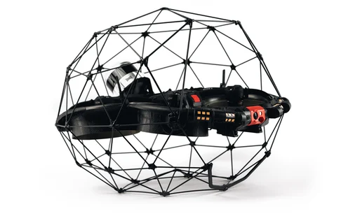 The new Elios 3 LiDAR payload unlocks more capabilities than the standard Rev 6.2
Completing a Road Bridge Survey Without Stopping Traffic

Methodology for Drone Mapping a Roadway Bridge
Results of the Road Bridge Survey with a Drone
Testing the Elios 3 Surveying Payload: Mapping a 600m bridge without disrupting traffic