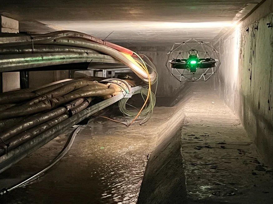
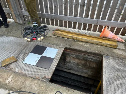
Safety Unpredictable conditions in the galleries made traditional inspection methods risky. The Elios 3 provided a safe, remote solution to collect data without exposing personnel to potential hazards like exposed wiring or unstable structures. Speed The drone enabled rapid data collection across different types of underground spaces, from tight corridors to open areas. This allowed for efficient mapping of 13 kilometers of complex environments in just a few days. Data Quality The Elios 3, equipped with LiDAR, was used over 9 intense days and completed 241 flights. A total of 1,776 points of interest were captured and analyzed by experts to assess the condition of the galleries accurately. Access The underground galleries are spread throughout the city, some of which are flooded or have limited access. The Elios 3 proved adaptable, allowing teams to inspect even the most challenging locations safely and effectively. Brussels, known as the "Capital of Europe," is a hub for international institutions and innovation. As a smart city, it uses technology to optimize operations, from traffic systems to infrastructure management. One key initiative involves mapping the vast network of underground technical galleries that support the city's utilities and infrastructure. To ensure the long-term maintenance and efficient use of these spaces, Brussels Mobility launched a project to survey and map the underground galleries. Many of these structures date back decades, with no accurate records available. The goal was to create a detailed as-built model of the galleries to support future planning and maintenance efforts. Brussels Mobility partnered with several companies to bring together expertise in engineering, data processing, and drone technology. SECO, an engineering firm, focused on structural assessments, while Sweco, a leading consultancy, handled data analysis and mapping. Medexon and Flywel, specialists in drone inspections, provided the Elios 3, a compact and durable drone ideal for confined spaces. This collaboration brought together a team of experts who could navigate the challenges of the underground environment, ensuring both safety and precision in the data collected. Sweco used LiDAR and visual imagery to generate 2D maps and 3D cross-sections of the galleries, while Medexon-Flywel deployed the Elios 3 to scout hazardous areas and gather high-quality data in difficult-to-reach spots. The primary objectives of the project were to: Despite the complexity of the environment, the Elios 3 performed exceptionally well. It was used for over 200 flights, collecting LiDAR and visual data across 13 kilometers of tunnels, storm drains, and technical rooms. The team faced challenges such as waterlogged areas, blocked passages, and electrical hazards. The Elios 3’s ability to operate in GPS-denied environments made it an essential tool for both scouting and data collection. The Elios 3’s Surveying Payload proved especially useful in tough conditions, including storm drains where traditional LiDAR scanners struggled. In some cases, the team manually held the drone to capture data in tight spaces where flying wasn’t possible. Throughout the project, the team worked closely with Flyability to refine their LiDAR datasets and reduce drift, ensuring the final maps were as accurate as possible. The resulting LiDAR maps provide a clear view of the underground infrastructure, helping planners identify access points, plan maintenance, and consider future repurposing of the spaces. The project spanned over 13 kilometers of tunnels, storm drains, and technical rooms. With 241 flights conducted over nine days, the team successfully gathered 1,776 points of interest, providing a comprehensive dataset for analysis. Thanks to the collaborative effort between all partners, the final maps are now ready to support future maintenance, repairs, and potential new uses for the underground spaces. The success of this project has opened the door for similar initiatives in other cities. As drone technology continues to evolve, solutions like the Elios 3 will play an increasingly important role in making underground inspections faster, safer, and more accurate. Discover more about the Elios 3 and its specialized LiDAR payload. All images in this article are credited to CLP Power. Injection Molds,Injection Molding Part,Plastic Molding Injection,Plastic Injection Moulds Shenzhen Yuheng Precision Machinery Co., Ltd. , https://www.yhcncmachiningparts.comMapping 13 Kilometers of Underground Technical Galleries in Brussels
Key Benefits at a Glance
Building a Specialized Survey Team
Underground Surveys with the Elios 3
Complex Mapping with a Drone
Surveying 13 Kilometers with the Elios 3
Mapping 13 kilometers of underground technical galleries in Brussels